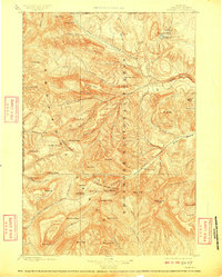
1899 Map of Crandall
USGS Topo · Published 1909About this map
The Sunlight Mining Region serves as the economic centerpiece of this late 19th-century reconnaissance, capturing a high-altitude wilderness on the cusp of industrial interest. Located just east of the Yellowstone National Park boundary, the landscape is defined by the headwaters of the Clark Fork and the dramatic topography of Sunlight Basin. Geographer A.H. Thompson and topographer Frank Tweedy documented a region of extreme verticality, where prominent landmarks like Stinkingwater Peak and Pilot Peak guided early travelers and prospectors alike. The map illustrates the early boundaries of the Shoshone National Forest, preserving a record of the drainage patterns and glacial cirques such as Silvertip Basin and Hoodoo Basin before modern road networks penetrated these high ranges.
Find a feature on this map
75 named features on this map. Tap any name to fly to it.
Don’t see what you’re looking for? This feature index may not catch every label — zoom into the map to look around manually.
Map Details
Editions of this 1899 Crandall Map
4 editions found

Other maps of this area

1885 · Lake
USGS Topo · 1:125,000

1886 · Canyon
USGS Topo · 1:125,000

1891 · Livingston
USGS Topo · 1:250,000

1893 · Livingston
USGS Topo · 1:250,000

1893 · Ishawooa
USGS Topo · 1:125,000

1895 · Ishawooa
USGS Topo · 1:125,000

1895 · Canyon
USGS Topo · 1:125,000

1895 · Lake
USGS Topo · 1:125,000

1896 · Lake
USGS Topo · 1:125,000

1896 · Canyon
USGS Topo · 1:125,000