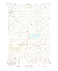
1957 Map of Crane Creek Reservoir
USGS Topo · Published 1977About this map
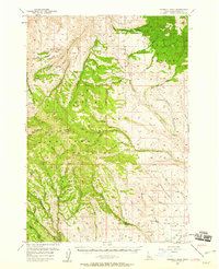
Midvale sits at the confluence of the Weiser River and its middle fork, serving as a valley hub for the Union Pacific railroad corridor during the mid-1950s. The landscape transitioning east from the river is dominated by complex water management and high desert terrain, centered on the significant Crane Creek Reservoir. The map documents a rural infrastructure in transition, noting the Cozy Corners School (Aban'd) and the South Crane Sch as local landmarks among the draws and flats. To the south, Sugarloaf and Ant Butte rise above Paddock Valley, while the north is marked by Dutch Flat and Dixie Creek. This survey captures the detailed hydraulic network of the era, from the Gaging Sta below the main dam to various smaller catchments like the Little Crane Creek Reservoir and Soulen Res.
Find a feature on this map
40 named features on this map. Tap any name to fly to it.
Don’t see what you’re looking for? This feature index may not catch every label — zoom into the map to look around manually.
Map Details
Editions of this 1957 Crane Creek Reservoir Map
2 editions found
Other maps of this area

1894 · Squaw Creek
USGS Topo · 1:125,000

1897 · Weiser
USGS Topo · 1:125,000

1911 · Meadows
USGS Topo · 1:125,000

1952 · Weiser Cove
USGS Topo · 1:24,000

1953 · Mann Creek
USGS Topo · 1:62,500
1954 · Council
USGS Topo · 1:62,500

1955 · Baker
USGS Topo · 1:250,000
1957 · Cambridge
USGS Topo · 1:62,500
1957 · Crane Creek Reservoir
USGS Topo · 1:62,500
1957 · Sturgill Peak
USGS Topo · 1:62,500