1905 Map of Crapo
USGS Topo · Published 1934About this map
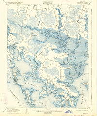
Middle Hoopers Island and the intricate marshlands of Dorchester County define this turn-of-the-century coastal landscape. The region's isolation and maritime economy are evident in the scatter of small settlements like Hoopersville and Elliott Island, which rely on a complex network of waterways including the Blackwater River, Transquaking River, and Slaughter Creek. Topographers J.R. Eakin and T.G. Basinger documented a terrain dominated by tidal necks such as Meekins Neck and Kerwin Neck, alongside an extensive system of man-made drainage like Keene Ditch and Booze Ditch. The presence of the Steamboat Route in the Honga and Fishing Bay emphasizes the importance of waterborne transport before the expansion of modern road systems. This environment of ponds, such as Barbadoes Pond and Backgarden Pond, reflects a fragile balance between land and the Chesapeake Bay, preserving the locations of landings like Barnes Landing and Robbins Ldg used by generations of watermen.
Find a feature on this map
112 named features on this map. Tap any name to fly to it.
Don’t see what you’re looking for? This feature index may not catch every label — zoom into the map to look around manually.
Map Details
Editions of this 1905 Crapo Map
3 editions found


Other maps of this area

1892 · Drum Point
USGS Topo · 1:62,500

1893 · Sharps Island
USGS Topo · 1:62,500

1894 · Point Lookout
USGS Topo · 1:62,500

1898 · Choptank
USGS Topo · 1:125,000

1898 · St. Marys
USGS Topo · 1:125,000

1901 · Drum Point
USGS Topo · 1:62,500

1903 · Nanticoke
USGS Topo · 1:62,500

1903 · Bloodsworth Island
USGS Topo · 1:62,500

1903 · Deal Island
USGS Topo · 1:62,500

1904 · Sharps Island
USGS Topo · 1:62,500