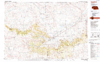
1986 Map of Crawford
USGS Topo · Published 1989About this map
Pine Ridge and the Oglala National Grassland dominate this corner of the Nebraska Panhandle, showcasing a landscape defined by dramatic escarpments and high plains ranching. The 1980s infrastructure reveals a critical transportation hub centered on Crawford, where the Chicago and North Western and Burlington Northern railroads intersect. This rail network, alongside Us 20, historically supported the region's agricultural and military significance, most notably at the Fort Robinson Military Reservation and the adjacent Fort Robinson State Park.
Find a feature on this map
77 named features on this map. Tap any name to fly to it.
Don’t see what you’re looking for? This feature index may not catch every label — zoom into the map to look around manually.
Map Details
Editions of this 1986 Crawford Map
2 editions found
Other maps of this area

1896 · Oelrichs
USGS Topo · 1:125,000

1896 · Patrick
USGS Topo · 1:125,000

1899 · Whistle Creek
USGS Topo · 1:125,000

1900 · Oelrichs
USGS Topo · 1:125,000

1902 · Edgemont
USGS Topo · 1:125,000

1946 · Box Butte Reservoir West
USGS Topo · 1:24,000

1947 · Box Butte NW
USGS Topo · 1:24,000

1948 · Box Butte Reservoir West
USGS Topo · 1:24,000

1948 · Box Butte Reservoir East
USGS Topo · 1:24,000

1949 · Box Butte NW
USGS Topo · 1:24,000