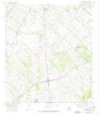
1968 Map of Creedmoor
USGS Topo · Published 1974About this map
The agricultural lands of southern Travis County meet the borders of Bastrop, Hays, and Caldwell counties in this 1968 study, revised in the early 1970s. The settlement of Creedmoor serves as a central hub for a network of family-named roads such as Sassman Road and Von Quintus Road, reflecting the deeply rooted rural communities of the era. The landscape is defined by the drainage of Maha Creek and Cedar Creek, where small family cemeteries and local congregations underscore the area's genealogical significance. Researchers will find numerous burial sites including Creedmoor Cem and Vasquez Cem, alongside religious landmarks like Center Union Ch. The transition from northern Travis County toward Niederwald and Mendoza shows a landscape still dominated by wide acreage and natural draws like Cowpen Creek, just before the significant suburban expansion of the late 20th century.
Find a feature on this map
48 named features on this map. Tap any name to fly to it.
Don’t see what you’re looking for? This feature index may not catch every label — zoom into the map to look around manually.
Map Details
Editions of this 1968 Creedmoor Map
4 editions found
Other maps of this area

1896 · Austin
USGS Topo · 1:125,000

1897 · Austin
USGS Topo · 1:125,000

1910 · Austin
USGS Topo · 1:125,000

1911 · San Marcos
USGS Topo · 1:125,000

1919 · San Marcos
USGS Topo · 1:125,000

1930 · Lockhart
USGS Topo · 1:62,500

1953 · Seguin
USGS Topo · 1:250,000

1954 · Austin
USGS Topo · 1:250,000

1955 · Montopolis
USGS Topo · 1:24,000

1955 · Oak Hill
USGS Topo · 1:24,000