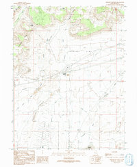
1991 Map of Crescent Junction
USGS Topo · Published 1991About this map
Crescent Junction serves as the focal point of this arid landscape, situated where highway and rail corridors intersect beneath the towering heights of Christmas Ridge. The map illustrates a region defined by its transit history and geological features, including the Old RR Grade and a Landing Strip that suggest the area's importance as a crossroads in eastern Utah. To the north, the terrain rises sharply toward Horse Heaven and Thompson Pass, while the southern portion of the sheet is dominated by the broad, sloping expanse of Crescent Bench and the intricate geological formations of the Crescent Dikes. Numerous dry washes, such as Crooked Wash and Thompson Wash, carve through the desert floor, leading toward the Valley City Reservoir. This survey captures the utilitarian nature of the landscape, noting various Prospects and Gravel Pits that hint at the local extractive industry during the late twentieth century.
Find a feature on this map
29 named features on this map. Tap any name to fly to it.
Don’t see what you’re looking for? This feature index may not catch every label — zoom into the map to look around manually.
Map Details
Editions of this 1991 Crescent Junction Map
This is the sole edition of this map. No revisions or reprints were ever made.
Other maps of this area

1885 · East Tavaputs
USGS Topo · 1:250,000

1885 · La Sal
USGS Topo · 1:250,000

1956 · Moab
USGS Topo · 1:250,000

1956 · Grand Junction
USGS Topo · 1:250,000

1958 · Crescent Junction
USGS Topo · 1:62,500

1958 · Thompson
USGS Topo · 1:62,500

1959 · Grand Junction
USGS Topo · 1:250,000

1959 · Moab
USGS Topo · 1:250,000

1960 · Moab
USGS Topo · 1:250,000

1960 · Grand Junction
USGS Topo · 1:250,000