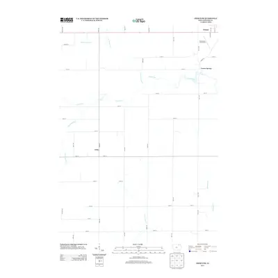
2013 Map of Cresco SW
USGS Topo · Published 2013About this map
Cresco anchors the northeast corner of this Howard County landscape, where the town's grid begins to give way to the agricultural expanses of northern Iowa. The drainage of the Turkey River and its various tributaries, including the N Br Turkey River and W Br Turkey River, create a wandering network of water across the northern half of the quadrangle. Further south, the rural character is defined by long, straight section-line roads like Saint Ave and Timber Ave, which connect the small settlements of Vernon Springs and Schley. Aviation history is present at the Ellen Church Field Airport, situated just south of the main Cresco township. The map's detailed road network reveals the high density of family farmsteads typical of the region, while waterways like Little Turkey Cr and Bohemian Cr dictate the subtle shifts in the otherwise orderly grid of Howard County.
Find a feature on this map
36 named features on this map. Tap any name to fly to it.
Don’t see what you’re looking for? This feature index may not catch every label — zoom into the map to look around manually.
Map Details
Editions of this 2013 Cresco SW Map
This is the sole edition of this map. No revisions or reprints were ever made.
Other maps of this area

1954 · Mason City
USGS Topo · 1:250,000

1957 · Mason City
USGS Topo · 1:250,000

1958 · Mason City
USGS Topo · 1:250,000

1972 · Jerico
USGS Topo · 1:24,000

1981 · Lourdes
USGS Topo · 1:24,000

1981 · Cresco NW
USGS Topo · 1:24,000
1981 · Cresco NE
USGS Topo · 1:24,000

1981 · Lime Springs
USGS Topo · 1:24,000
1981 · Saude
USGS Topo · 1:24,000
1981 · Cresco SE
USGS Topo · 1:24,000