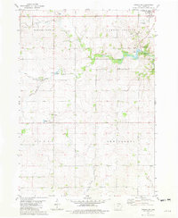
1981 Map of Cresco SW
USGS Topo · Published 1982About this map
The Turkey River and its multiple tributaries define the drainage and settlement patterns of this Howard County landscape in the early 1980s. The township divisions of Howard Center, Vernon Springs, Paris, and New Oregon organize a largely agrarian region marked by scattered rural infrastructure. The historic community of Vernon Springs sits near the Vernon Springs County Park, while the smaller settlement of Schley is located further south near Holy Cross Ch. Diverse watercourses including the West Branch North Turkey River, South Branch Turkey River, and Bohemian Creek highlight the intricate hydrography of the area. Local industry and recreation are represented by several Gravel Pit operations, a Quarry, and the local Golf Course.
Find a feature on this map
21 named features on this map. Tap any name to fly to it.
Don’t see what you’re looking for? This feature index may not catch every label — zoom into the map to look around manually.
Map Details
Editions of this 1981 Cresco SW Map
This is the sole edition of this map. No revisions or reprints were ever made.
Other maps of this area

1954 · Mason City
USGS Topo · 1:250,000

1957 · Mason City
USGS Topo · 1:250,000

1958 · Mason City
USGS Topo · 1:250,000

1972 · Jerico
USGS Topo · 1:24,000

1981 · Lourdes
USGS Topo · 1:24,000

1981 · Cresco NW
USGS Topo · 1:24,000
1981 · Cresco NE
USGS Topo · 1:24,000

1981 · Lime Springs
USGS Topo · 1:24,000
1981 · Saude
USGS Topo · 1:24,000
1981 · Cresco SE
USGS Topo · 1:24,000