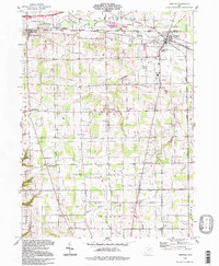
1994 Map of Creston
USGS Topo · Published 1997About this map
The boundary line between Medina Co and Wayne Co bisects this landscape where the village of Creston serves as a vital junction for the Baltimore and Ohio and Norfolk and Western railroads. These transit corridors frame a region defined by agricultural townships and small rural centers like Burbank, Jackson, and Canaan. The mapping reflects a deeply rooted community infrastructure, notably preserving the location of the County Home for the Aged and the Norwayne High Sch. Waterways like Killbuck Creek and Camel Creek wind through the northern sections, while numerous family and community burial grounds, including Maple Mound Cem and Canaan Bend Cem, provide essential data points for local genealogists. The presence of an old railroad grade and a Sand and Gravel Pit near the village suggests a shift from earlier industrial uses toward the more modern utility of the regional pipeline network.
Find a feature on this map
41 named features on this map. Tap any name to fly to it.
Don’t see what you’re looking for? This feature index may not catch every label — zoom into the map to look around manually.
Map Details
Editions of this 1994 Creston Map
This is the sole edition of this map. No revisions or reprints were ever made.
Other maps of this area

1901 · Wooster
USGS Topo · 1:62,500

1903 · Wooster
USGS Topo · 1:62,500

1904 · Medina
USGS Topo · 1:62,500

1904 · Wellington
USGS Topo · 1:62,500

1906 · Medina
USGS Topo · 1:62,500

1906 · Wellington
USGS Topo · 1:62,500

1906 · West Salem
USGS Topo · 1:62,500

1908 · West Salem
USGS Topo · 1:62,500

1950 · Cleveland
USGS Topo · 1:250,000

1950 · Marion
USGS Topo · 1:250,000