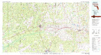
1978 Map of Crestview
USGS Topo · Published 1982About this map
Crestview serves as the central hub of this late-1970s landscape, where the Louisville and Nashville Railroad cuts an east-west path through the Florida Panhandle. The map reveals a region defined by massive public and military tracts, most notably the northern reaches of Eglin Air Force Base and the dense woodlands of the Blackwater River State Forest. To the north, the boundary between Alabama and Florida is marked by small settlements like Laurel Hill and Paxton near the Conecuh National Forest.
Find a feature on this map
87 named features on this map. Tap any name to fly to it.
Don’t see what you’re looking for? This feature index may not catch every label — zoom into the map to look around manually.
Map Details
Editions of this 1978 Crestview Map
2 editions found
Other maps of this area

1920 · Milton
USGS Topo · 1:62,500

1921 · Holley
USGS Topo · 1:62,500

1921 · Pensacola
USGS Topo · 1:62,500

1934 · Holt
USGS Topo · 1:48,000

1934 · Harold
USGS Topo · 1:62,500

1934 · Niceville
USGS Topo · 1:48,000

1935 · Villa Tasso
USGS Topo · 1:48,000

1935 · De Funiak Springs
USGS Topo · 1:48,000

1936 · Niceville
USGS Topo · 1:62,500

1936 · Point Washington
USGS Topo · 1:48,000