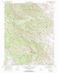
1955 Map of Crevison Peak
USGS Topo · Published 1972About this map
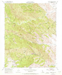
Crevison Peak stands as the central landmark of this mid-century survey, which maps a high-relief section of the Diablo Range spanning the boundary between Stanislaus Co and Merced Co. The landscape is defined by a dense network of watercourses, including Garzas Creek, Quinto Creek, and the headwaters of Pacheco Creek, all carving deep gulches through the arid hills. While much of the terrain is characterized by its dramatic topography, early ranching and seasonal habitation are evident at Richey Camp, China Cabin Flat, and the Fifield Ranch. The presence of numerous windmills and springs, such as Reeves Spring and McDowell Spr, points to the vital importance of water management in these grazing lands. Smaller upland water bodies like Dry Lake and Bass Lake provide focal points within the higher elevations, while a network of jeep trails indicates the remote accessibility of the region during this era of topographic mapping.
Find a feature on this map
50 named features on this map. Tap any name to fly to it.
Don’t see what you’re looking for? This feature index may not catch every label — zoom into the map to look around manually.
Map Details
Editions of this 1955 Crevison Peak Map
6 editions found
Other maps of this area

1917 · Newman
USGS Topo · 1:31,680

1919 · Orestimba
USGS Topo · 1:62,500

1919 · Orestimba Creek
USGS Topo · 1:31,680

1920 · Pacheco Pass
USGS Topo · 1:62,500

1921 · Gilroy Hot Springs
USGS Topo · 1:62,500

1922 · San Luis Creek
USGS Topo · 1:31,680

1922 · Howard Ranch
USGS Topo · 1:31,680

1938 · Mt. Boardman
USGS Topo · 1:62,500

1939 · Gilroy Hot Springs
USGS Topo · 1:62,500

1940 · Gilroy Hot Springs
USGS Topo · 1:62,500