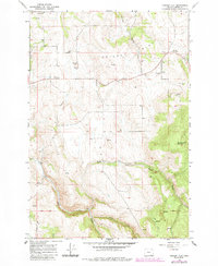
1964 Map of Cricket Flat
USGS Topo · Published 1985About this map
Cricket Flat defines the high plateau of Union County in this mid-1960s topographic record, updated with forest revisions through the early 1980s. The area's community identity is anchored by local gathering places like the Cricket Flat Grange Hall and Pine Grove Church. This map provides significant genealogical value, documenting the Highland Cem and Pine Grove Cem alongside family-named landmarks such as Stubblefield Mountain and Rysdam Canyon. The landscape is etched by a drainage network comprising the North Fork Clark Creek, Middle Fork Clark Creek, and Clark Creek. Evidence of local industry and infrastructure is seen in several Borrow Pit and Gravel Pit locations near the highway and the winding Deer Creek Trail, reflecting the intersection of timber, transit, and rural settlement at Minam Summit.
Find a feature on this map
23 named features on this map. Tap any name to fly to it.
Don’t see what you’re looking for? This feature index may not catch every label — zoom into the map to look around manually.
Map Details
Editions of this 1964 Cricket Flat Map
2 editions found
Other maps of this area

1906 · Telocaset
USGS Topo · 1:125,000

1955 · Grangeville
USGS Topo · 1:250,000

1959 · Grangeville
USGS Topo · 1:250,000

1964 · Partridge Creek
USGS Topo · 1:24,000

1964 · Howard Butte
USGS Topo · 1:24,000

1964 · Cricket Flat
USGS Topo · 1:24,000

1964 · Minam
USGS Topo · 1:24,000

1964 · Elgin
USGS Topo · 1:24,000

1964 · Rondowa
USGS Topo · 1:24,000
1965 · Gasset Bluff
USGS Topo · 1:24,000