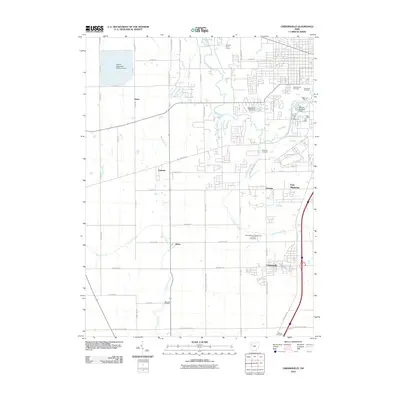
2010 Map of Cridersville
USGS Topo · Published 2010About this map
Cridersville and Fort Shawnee anchor this landscape south of Lima, where the transition from organized suburban blocks to open agricultural land is punctuated by numerous historic burial sites. The area is defined by the winding course of the Ottawa River and the Little Ottawa River, which are managed through infrastructure like the McClintock Lake Dam and the Refinery Reservoir Dam. In the rural western and southern stretches, smaller settlements such as Hume, Oakview, and Kemp appear along a grid of farm-to-market roads, including Wapakoneta Cridersville Rd and Fort Amanda Rd. The presence of several legacy cemeteries, including Wheeler Cemetery and Gethsemane Cemetery, offers significant detail for researchers tracing local family lineages. Large-scale water management projects like the Bresler Upground Reservoir Dam dominate the northwest, contrasting with the leisure space of the Tamarac Golf Course.
Find a feature on this map
61 named features on this map. Tap any name to fly to it.
Don’t see what you’re looking for? This feature index may not catch every label — zoom into the map to look around manually.
Map Details
Editions of this 2010 Cridersville Map
This is the sole edition of this map. No revisions or reprints were ever made.
Other maps of this area

1906 · Lima
USGS Topo · 1:62,500

1906 · Columbus Grove
USGS Topo · 1:62,500

1908 · Columbus Grove
USGS Topo · 1:62,500

1911 · Spencerville
USGS Topo · 1:62,500

1911 · Delphos
USGS Topo · 1:62,500

1944 · Delphos
USGS Topo · 1:62,500

1944 · Spencerville
USGS Topo · 1:62,500

1953 · Muncie
USGS Topo · 1:250,000

1956 · Muncie
USGS Topo · 1:250,000
1960 · Delphos
USGS Topo · 1:24,000