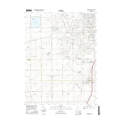
2016 Map of Cridersville
USGS Topo · Published 2016About this map
Lima and its southern suburbs occupy the northern edge of this 2016 survey, where the Ottawa River and McClintock Lake define the suburban transition. Further south, the landscape shifts toward the organized townships of Allen and Auglaize Counties, marked by the distinct settlements of Cridersville and the Village of Fort Shawnee. The area is notably rich in early local history markers, including the Saint Mathews Evangelical Lutheran Cem and Wheeler Cem. The industrial and infrastructure character of the region is evident in the large Bresler Upground Reservoir to the northwest and the Refinery Reservoir near the city limits. Small hamlets like Hume and Kemp are situated along a network of historic rural routes such as National Rd and Spencerville Rd, illustrating the persistent agricultural framework that surrounds the growing communities of Oakview and Elmview.
Find a feature on this map
59 named features on this map. Tap any name to fly to it.
Don’t see what you’re looking for? This feature index may not catch every label — zoom into the map to look around manually.
Map Details
Editions of this 2016 Cridersville Map
This is the sole edition of this map. No revisions or reprints were ever made.
Other maps of this area

1906 · Lima
USGS Topo · 1:62,500

1906 · Columbus Grove
USGS Topo · 1:62,500

1908 · Columbus Grove
USGS Topo · 1:62,500

1911 · Spencerville
USGS Topo · 1:62,500

1911 · Delphos
USGS Topo · 1:62,500

1944 · Delphos
USGS Topo · 1:62,500

1944 · Spencerville
USGS Topo · 1:62,500

1953 · Muncie
USGS Topo · 1:250,000

1956 · Muncie
USGS Topo · 1:250,000
1960 · Delphos
USGS Topo · 1:24,000