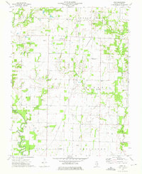
1973 Map of Crisp
USGS Topo · Published 1975About this map
The tiny settlement of Crisp and the surrounding farmland of Wayne County define this landscape in the early 1970s. This area is a patchwork of small-scale agriculture and active petroleum extraction, with numerous Oil Wells scattered across the northern and eastern sections, particularly within the Johnsonville South Oil Field and the Sims Oil Field. The terrain is shaped by the winding course of the Skillet Fork and its tributaries, including Crooked Creek and Little Dry Fork, which cut through local elevations like Hickory Hill and Linder Hill.
Find a feature on this map
43 named features on this map. Tap any name to fly to it.
Don’t see what you’re looking for? This feature index may not catch every label — zoom into the map to look around manually.
Map Details
Editions of this 1973 Crisp Map
This is the sole edition of this map. No revisions or reprints were ever made.
Other maps of this area

1947 · Wayne City
USGS Topo · 1:62,500

1948 · Fairfield
USGS Topo · 1:62,500

1948 · Flora
USGS Topo · 1:62,500

1949 · Flora
USGS Topo · 1:62,500

1952 · Xenia
USGS Topo · 1:62,500

1958 · Belleville
USGS Topo · 1:250,000

1962 · Belleville
USGS Topo · 1:250,000
1968 · Orchardville
USGS Topo · 1:24,000
1968 · Johnsonville
USGS Topo · 1:24,000
1970 · Cisne
USGS Topo · 1:24,000