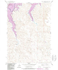
1956 Map of Crockett Mountains
USGS Topo · Published 1987About this map
Lake Oahe dominates the northern reaches of this landscape, its fingers reaching into the rugged breaks where the Cheyenne River once flowed freely before inundation. This mid-century survey reflects the massive hydraulic changes of the Missouri River Basin project, showing the reservoir at its normal pool elevation of 1617 feet. The water cuts deeply into the southern edge of the Cheyenne River Indian Reservation Boundary, creating a stark contrast between the flooded valley and the high, arid plains of Stanley County.
Find a feature on this map
15 named features on this map. Tap any name to fly to it.
Don’t see what you’re looking for? This feature index may not catch every label — zoom into the map to look around manually.
Map Details
Editions of this 1956 Crockett Mountains Map
2 editions found
Other maps of this area

1954 · Pierre
USGS Topo · 1:250,000

1956 · Rousseau Creek SW
USGS Topo · 1:24,000

1956 · Herbert Creek SE
USGS Topo · 1:24,000

1956 · Sansarc NE
USGS Topo · 1:24,000

1956 · Crockett Mountains
USGS Topo · 1:24,000

1958 · Pierre
USGS Topo · 1:250,000

1969 · Rousseau Creek
USGS Topo · 1:24,000

1982 · Sansarc
USGS Topo · 1:24,000

1982 · Mission Ridge
USGS Topo · 1:24,000

1983 · Standing Butte
USGS Topo · 1:24,000