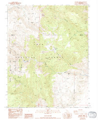
1987 Map of Crooked Creek
USGS Topo · Published 1994About this map
Inyo National Forest and the Ancient Bristlecone Pine Forest define this high-altitude landscape in eastern California. The terrain is marked by sharp elevation changes, from peaks like Sage Hen Peak and Iron Mountain to the depths of Royal Gorge. This 1980s survey captures the area's history of extraction and subsistence, documenting the Wilkerson Mine and Southbend Mine alongside numerous prospects scattered across the ridges. Evidence of early land use is found at Roberts Ranch, situated near the headwaters of Wyman Creek. The drainage patterns are intricate, with Crooked Creek and Cottonwood Creek carving through the mountains, while features like Dead Horse Meadow suggest the importance of seasonal grazing or natural clearings in an otherwise formidable environment. The map also delineates the boundary between Mono and Inyo counties, illustrating how political lines were drawn across this complex topography.
Find a feature on this map
21 named features on this map. Tap any name to fly to it.
Don’t see what you’re looking for? This feature index may not catch every label — zoom into the map to look around manually.
Map Details
Editions of this 1987 Crooked Creek Map
2 editions found
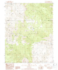
Other maps of this area

1898 · Silver Peak
USGS Topo · 1:125,000

1900 · Silver Peak
USGS Topo · 1:125,000

1908 · Lida
USGS Topo · 1:250,000

1913 · Bishop
USGS Topo · 1:125,000

1913 · Lida
USGS Topo · 1:250,000

1917 · White Mountain
USGS Topo · 1:125,000

1947 · Mariposa
USGS Topo · 1:250,000

1948 · Mariposa
USGS Topo · 1:250,000

1951 · Blanco Mountain
USGS Topo · 1:62,500

1954 · Goldfield
USGS Topo · 1:250,000