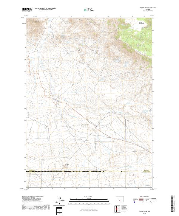
2021 Map of Crooks Peak
USGS Topo · Published 2021About this map
Crooks Peak and the high ridges of Sheep Mtn dominate this central Wyoming landscape, where the high desert meets the northern foothills. The area is defined by the passage of the Continental Divide National Scenic Trl, which winds through the terrain near Crooks Gap. This pass serves as a primary corridor through the hills, followed by Crooks Gap Rd as it connects the northern basins with the southern plains. The drainage patterns are intricate, with Crooks Cr and the W Fork Crooks Cr feeding into the Crooks Cr Reservoir near Taggart Meadows. To the south, the landscape shifts toward the distinct volcanic or erosional profile of Bare Ring Butte and the seasonal hydrology of Bare Ring Slough. The boundary between Fremont and Sweetwater counties crosses the southern portion of the map, marking a transition in this remote rangeland.
Find a feature on this map
26 named features on this map. Tap any name to fly to it.
Don’t see what you’re looking for? This feature index may not catch every label — zoom into the map to look around manually.
Map Details
Editions of this 2021 Crooks Peak Map
This is the sole edition of this map. No revisions or reprints were ever made.
Other maps of this area

1951 · Crooks Creek NE
USGS Topo · 1:24,000

1951 · Split Rock NW
USGS Topo · 1:24,000

1951 · Crooks Mountain
USGS Topo · 1:24,000

1955 · Casper
USGS Topo · 1:250,000

1957 · Jeffrey City
USGS Topo · 1:24,000

1958 · Casper
USGS Topo · 1:250,000
1961 · Osborne Well
USGS Topo · 1:24,000
1961 · Antelope Reservoir
USGS Topo · 1:24,000

1961 · Hadsell Spring
USGS Topo · 1:24,000

1961 · Crooks Peak
USGS Topo · 1:24,000