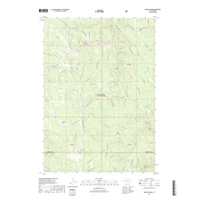
2017 Map of Crooks Tower
USGS Topo · Published 2017About this map
Black Hills National Forest occupies the high country of South Dakota's Black Hills in this 2017 survey, centered on the landmark Crooks Tower. The landscape is defined by a dense network of forest roads such as Tinton Rd and Co Rd 117, which navigate complex drainages including Clayton Draw and Intake Gulch. The map reveals a high-elevation environment where seasonal water sources like Potato Spring, Morrow Spring, and Lander Spring are critical features among the timbered ridges. Notable for its unusual nomenclature, the area includes a series of specific cliffs such as Eagle Cliff What The Hell and Eagle Cliff Hamburger. These labels suggest a localized naming tradition likely tied to early timber, mining, or recreational activities within the national forest. Open meadows like Stovehole Park and Well Park provide breaks in the terrain, while the boundary between Lawrence Co and Pennington Co cuts across the southern portion of the quadrangle.
Find a feature on this map
102 named features on this map. Tap any name to fly to it.
Don’t see what you’re looking for? This feature index may not catch every label — zoom into the map to look around manually.
Map Details
Editions of this 2017 Crooks Tower Map
This is the sole edition of this map. No revisions or reprints were ever made.
Other maps of this area

1894 · Deadwood
USGS Topo · 1:125,000

1898 · Sundance
USGS Topo · 1:125,000

1900 · Spearfish
USGS Topo · 1:62,500

1901 · Deadwood
USGS Topo · 1:125,000

1902 · Sundance
USGS Topo · 1:125,000

1915 · Spearfish
USGS Topo · 1:62,500

1916 · Deadwood
USGS Topo · 1:125,000

1953 · Rapid City
USGS Topo · 1:250,000

1954 · Gillette
USGS Topo · 1:250,000

1955 · Gillette
USGS Topo · 1:250,000