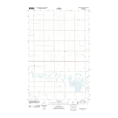
2010 Map of Crookston SW
USGS Topo · Published 2010About this map
Red Lake River meanders across the southern half of this landscape, its tight oxbows and serpentining path creating a complex riparian corridor in Polk County. This 2009–2010 survey period shows the persistent agricultural grid of the Red River Valley, where small settlements like Hixon and Ross are linked by a dense network of county roads. The importance of local heritage and family roots is evident in the presence of Union Cemetery near the river's bend and Calvary Cemetery further east. Away from the main river channel, Burnham Creek cuts through the southwestern corner, reflecting the low-lying drainage patterns that characterize this fertile region. The map preserves the exact placement of rural intersections and property access points as they existed before the transition into more modern digital mapping standards.
Find a feature on this map
19 named features on this map. Tap any name to fly to it.
Don’t see what you’re looking for? This feature index may not catch every label — zoom into the map to look around manually.
Map Details
Editions of this 2010 Crookston SW Map
This is the sole edition of this map. No revisions or reprints were ever made.
Other maps of this area

1919 · Eldred
USGS Topo · 1:62,500

1919 · Beltrami
USGS Topo · 1:62,500

1952 · Grand Forks
USGS Topo · 1:250,000

1953 · Crookston
USGS Topo · 1:62,500

1956 · Grand Forks
USGS Topo · 1:250,000
1963 · Key West
USGS Topo · 1:24,000

1964 · Girard
USGS Topo · 1:24,000

1964 · Greenview
USGS Topo · 1:24,000
1964 · Fisher
USGS Topo · 1:24,000
1964 · Eldred
USGS Topo · 1:24,000