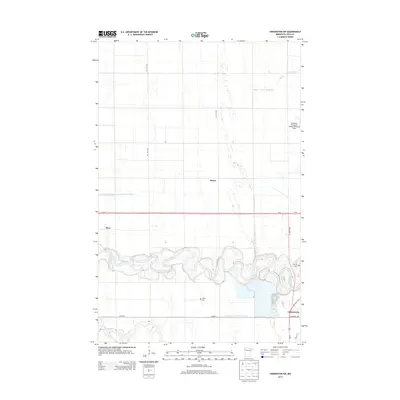
2013 Map of Crookston SW
USGS Topo · Published 2013About this map
The Red Lake River carves a deeply meandering path across the landscape southwest of Crookston, its tight oxbows contrasting with the rigid grid of the surrounding agricultural township. This 2013 survey documents a region defined by sophisticated water management, where numerous engineered channels like County Ditch Number One and County Ditch Number Sixtytwo support the fertile Red River Valley plains. The small settlements of Ross and Hixon appear as tiny nodes in this expanse, while the Crookston Municipal Airport-Kirkwood Field serves as a modern landmark to the north. Local heritage is rooted in the prairie, with Union Cem and Calvary Cem marking the historical presence of early families near the river's bend and along Town Hwy 75.
Find a feature on this map
21 named features on this map. Tap any name to fly to it.
Don’t see what you’re looking for? This feature index may not catch every label — zoom into the map to look around manually.
Map Details
Editions of this 2013 Crookston SW Map
This is the sole edition of this map. No revisions or reprints were ever made.
Other maps of this area

1919 · Eldred
USGS Topo · 1:62,500

1919 · Beltrami
USGS Topo · 1:62,500

1952 · Grand Forks
USGS Topo · 1:250,000

1953 · Crookston
USGS Topo · 1:62,500

1956 · Grand Forks
USGS Topo · 1:250,000
1963 · Key West
USGS Topo · 1:24,000

1964 · Girard
USGS Topo · 1:24,000

1964 · Greenview
USGS Topo · 1:24,000
1964 · Fisher
USGS Topo · 1:24,000
1964 · Eldred
USGS Topo · 1:24,000