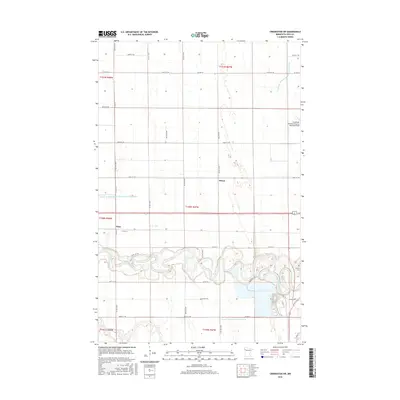
2016 Map of Crookston SW
USGS Topo · Published 2016About this map
Red Lake River meanders sharply through the southern reaches of this Polk County landscape, its tight oxbows and riparian wetlands contrasting with the rigid section lines of the surrounding prairie. This area, southwest of the city center, shows a transition from rural agricultural plots to the infrastructural edges of the community. In the northeast, the Crookston Municipal Airport-Kirkwood Field occupies a large tract, while the small settlements of Hixon and Ross anchor the central and western sections of the map.
Find a feature on this map
32 named features on this map. Tap any name to fly to it.
Don’t see what you’re looking for? This feature index may not catch every label — zoom into the map to look around manually.
Map Details
Editions of this 2016 Crookston SW Map
This is the sole edition of this map. No revisions or reprints were ever made.
Other maps of this area

1919 · Eldred
USGS Topo · 1:62,500

1919 · Beltrami
USGS Topo · 1:62,500

1952 · Grand Forks
USGS Topo · 1:250,000

1953 · Crookston
USGS Topo · 1:62,500

1956 · Grand Forks
USGS Topo · 1:250,000
1963 · Key West
USGS Topo · 1:24,000

1964 · Girard
USGS Topo · 1:24,000

1964 · Greenview
USGS Topo · 1:24,000
1964 · Fisher
USGS Topo · 1:24,000
1964 · Eldred
USGS Topo · 1:24,000