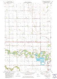
1982 Map of Crookston SW
USGS Topo · Published 1982About this map
The meandering Red Lake River dominates the southern landscape of this Polk County region, carving deep oxbows through the flat agricultural plains of Lowell and Andover townships. At the southeastern corner, the outskirts of Crookston emerge as a local hub of transport and infrastructure, marked by the Burlington Northern railroad lines and Crookston Junction. The map details a transition from the dense network of drainage canals like County Ditch No 26 to the industrial and municipal facilities south of the river, including a series of Sewage Disposal Ponds and Industrial Waste Ponds. Historically significant sites for researchers include the Union Cem and Calvary Cem, alongside small rural points such as Shirley and Hixon Station that dot the rail corridors and country roads north of Burnham Creek.
Find a feature on this map
39 named features on this map. Tap any name to fly to it.
Don’t see what you’re looking for? This feature index may not catch every label — zoom into the map to look around manually.
Map Details
Editions of this 1982 Crookston SW Map
This is the sole edition of this map. No revisions or reprints were ever made.
Other maps of this area

1919 · Eldred
USGS Topo · 1:62,500

1919 · Beltrami
USGS Topo · 1:62,500

1952 · Grand Forks
USGS Topo · 1:250,000

1953 · Crookston
USGS Topo · 1:62,500

1956 · Grand Forks
USGS Topo · 1:250,000
1963 · Key West
USGS Topo · 1:24,000

1964 · Girard
USGS Topo · 1:24,000

1964 · Greenview
USGS Topo · 1:24,000
1964 · Fisher
USGS Topo · 1:24,000
1964 · Eldred
USGS Topo · 1:24,000