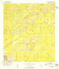
1954 Map of Cross City East
USGS Topo · Published 1955About this map
Cross City serves as the primary hub in this mid-century survey of Dixie County, where the transition from settlement to wilderness is clearly defined by the Atlantic Coast Line railroad and the Cross City Airport. The landscape is dominated by a complex system of seasonal wetlands and limestone sinks, including the extensive Tenmile Prairie and Delaney Prairie. These prairie lands, interspersed with numerous small bodies of water like Ocean Pond and Adams Lake, reflect the typical karst topography of the Florida Big Bend region.
Find a feature on this map
22 named features on this map. Tap any name to fly to it.
Don’t see what you’re looking for? This feature index may not catch every label — zoom into the map to look around manually.
Map Details
Editions of this 1954 Cross City East Map
3 editions found
Other maps of this area

1954 · Cross City West
USGS Topo · 1:24,000

1954 · Eugene
USGS Topo · 1:24,000

1954 · Cross City East
USGS Topo · 1:24,000

1954 · Mallory Swamp SW
USGS Topo · 1:24,000

1954 · Mallory Swamp SE
USGS Topo · 1:24,000

1954 · Cross City SW
USGS Topo · 1:24,000

1954 · Gainesville
USGS Topo · 1:250,000

1956 · Mallory Swamp SE
USGS Topo · 1:25,000

1958 · Gainesville
USGS Topo · 1:250,000

1959 · Gainesville
USGS Topo · 1:250,000