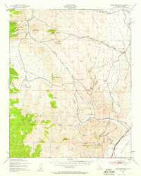
1943 Map of Cross Mountain
USGS Topo · Published 1959About this map
Mining and infrastructure define this landscape on the edge of the Mojave Desert during the mid-1940s. The presence of the Los Angeles Aqueduct winding through the canyons highlights the critical role of water transport in this arid region. High-country peaks like Cross Mountain and Mayan Peak tower over a network of isolated extraction sites, including the San Antonio Mine, Lone Star Mine, and Skyline Mine. These scattered operations suggest a period of active mineral exploration across the complex terrain of Butterbread Canyon and Jawbone Canyon.
Find a feature on this map
57 named features on this map. Tap any name to fly to it.
Don’t see what you’re looking for? This feature index may not catch every label — zoom into the map to look around manually.
Map Details
Editions of this 1943 Cross Mountain Map
5 editions found
Other maps of this area

1906 · Kernville
USGS Topo · 1:125,000

1908 · Kernville
USGS Topo · 1:125,000

1915 · Searles Lake
USGS Topo · 1:250,000

1915 · Mojave
USGS Topo · 1:125,000

1943 · Tehachapi
USGS Topo · 1:62,500

1943 · Inyokern
USGS Topo · 1:62,500

1943 · Cross Mountain
USGS Topo · 1:62,500

1943 · Emerald Mtn
USGS Topo · 1:62,500

1943 · Saltdale
USGS Topo · 1:62,500

1943 · Onyx
USGS Topo · 1:62,500