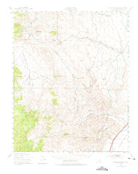
1943 Map of Cross Mountain
USGS Topo · Published 1975About this map
The high desert landscape of the Southern Sierra Nevada and Western Mojave is recorded here as it appeared in the mid-1940s. Centered on the distinctive Cross Mountain and Chuckwalla Mountain, this terrain shows a history of dispersed ranching and mining operations typical of the era. Evidence of early resource extraction is scattered throughout the canyons, including Bishops Claim, the San Antonio Mine, and the Skyline Mine. Local education and social hubs are sparse, marked by the solitary Landers Sch and the Dove Spring Ranch. Significant infrastructure cuts through the Fremont Valley, notably the Southern Pacific railroad and a major aqueduct, which contrast with the older network of springs and wells such as Butterbread Spring and Jawbone Well that historically sustained travel through the arid Jawbone Canyon.
Find a feature on this map
42 named features on this map. Tap any name to fly to it.
Don’t see what you’re looking for? This feature index may not catch every label — zoom into the map to look around manually.
Map Details
Editions of this 1943 Cross Mountain Map
5 editions found
Other maps of this area

1906 · Kernville
USGS Topo · 1:125,000

1908 · Kernville
USGS Topo · 1:125,000

1915 · Searles Lake
USGS Topo · 1:250,000

1915 · Mojave
USGS Topo · 1:125,000

1943 · Tehachapi
USGS Topo · 1:62,500

1943 · Inyokern
USGS Topo · 1:62,500

1943 · Cross Mountain
USGS Topo · 1:62,500

1943 · Emerald Mtn
USGS Topo · 1:62,500

1943 · Saltdale
USGS Topo · 1:62,500

1943 · Onyx
USGS Topo · 1:62,500