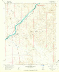
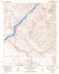
1959 Map of Cross Roads
USGS Topo · Published 1960About this map
The Colorado River serves as the focal point for this 1950s study of the borderlands between California and Arizona, carving through the gap between the Whipple Mountains and the Buckskin Mountains. Small riverside settlements like Cross Roads and Empire sit along the western bank, while Cienega Springs occupies a site just across the water. The landscape is heavily marked by early mining activity, particularly in the eastern heights where names like Billy Mack Mine, Gray Eagle Mine, and Carnation Mine indicate a history of mineral extraction. Large alluvial features such as Empire Flat and drainage systems like Osborne Wash and Bowmans Wash define the local topography. This map also preserves the inland reach of the Colorado River Indian Reservation Boundary, illustrating the intersection of natural geography, commercial enterprise, and administrative land divisions in the mid-20th century.
Find a feature on this map
30 named features on this map. Tap any name to fly to it.
Don’t see what you’re looking for? This feature index may not catch every label — zoom into the map to look around manually.
Map Details
Editions of this 1959 Cross Roads Map
5 editions found
Other maps of this area

1911 · Parker
USGS Topo · 1:125,000

1943 · Giers Basin
USGS Topo · 1:62,500

1943 · Whipple Mts.
USGS Topo · 1:62,500

1943 · Parker
USGS Topo · 1:62,500

1949 · Parker
USGS Topo · 1:62,500

1950 · Parker Dam Area
USGS Topo · 1:62,500

1950 · Parker
USGS Topo · 1:62,500

1950 · Whipple Mts
USGS Topo · 1:62,500

1952 · Whipple Mts
USGS Topo · 1:62,500

1954 · Needles
USGS Topo · 1:250,000