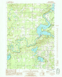
1985 Map of Croton
USGS Topo · Published 1985About this map
The Muskegon River serves as the central artery of this Newaygo County landscape, dominated by the significant reservoirs of Hardy Dam Pond and Croton Pond. The presence of Hardy Dam and Croton Dam illustrates the mid-century transformation of the river valley into a source of power and recreation. While much of the terrain is protected within the Manistee National Forest, residential pockets like Croton Heights and Riverview occupy the high ground overlooking the water.
Find a feature on this map
45 named features on this map. Tap any name to fly to it.
Don’t see what you’re looking for? This feature index may not catch every label — zoom into the map to look around manually.
Map Details
Editions of this 1985 Croton Map
This is the sole edition of this map. No revisions or reprints were ever made.
Other maps of this area

1954 · Midland
USGS Topo · 1:250,000

1958 · Midland
USGS Topo · 1:250,000

1958 · Sand Lake
USGS Topo · 1:62,500

1958 · Fremont
USGS Topo · 1:62,500

1958 · Woodville
USGS Topo · 1:62,500

1959 · Midland
USGS Topo · 1:250,000

1959 · White Cloud
USGS Topo · 1:62,500

1966 · Midland
USGS Topo · 1:250,000

1976 · White Cloud SE
USGS Topo · 1:24,000
1984 · Big Rapids
USGS Topo · 1:100,000