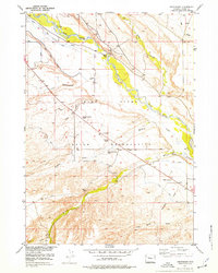
1952 Map of Crowheart
USGS Topo · Published 1977About this map
The Wind River Indian Reservation in central Wyoming is defined here by the wide valley of the Wind River and a complex network of irrigation infrastructure developed in the mid-20th century. This 1952 survey documents the irrigation landscape of the Missouri River Basin project, highlighting numerous labeled Ditch and Canal segments alongside an Aqueduct, a Flume, and a Surge Tank. Local life centers around the settlement of Crowheart, where the St Helen Church and the Burris-Crowheart School served the community. Further east, the small settlement of Lenore sits near the river, while the Government Ditch Camp indicates the organized labor required to maintain these water systems. The terrain transitions from the riparian bottomlands of the main river to numerous named drainage basins like Dry Creek, Meadow Creek, and Willow Creek, reflecting the importance of water management in this arid ranching and reservation landscape.
Find a feature on this map
23 named features on this map. Tap any name to fly to it.
Don’t see what you’re looking for? This feature index may not catch every label — zoom into the map to look around manually.
Map Details
Editions of this 1952 Crowheart Map
3 editions found
Other maps of this area

1951 · Bull Lake East
USGS Topo · 1:24,000

1952 · Wilderness
USGS Topo · 1:24,000

1952 · Crowheart Butte
USGS Topo · 1:24,000

1952 · Crowheart NW
USGS Topo · 1:24,000

1952 · Crowheart NE
USGS Topo · 1:24,000

1952 · Bull Lake West
USGS Topo · 1:24,000

1952 · Crowheart
USGS Topo · 1:24,000

1952 · Burris
USGS Topo · 1:24,000

1952 · Kirkland Park
USGS Topo · 1:24,000

1955 · Thermopolis
USGS Topo · 1:250,000