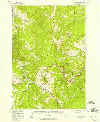
1955 Map of Crown Butte
USGS Topo · Published 1958This historical map portrays the area of Crown Butte in 1955, primarily covering Gallatin County as well as portions of Wyoming. Featuring a scale of 1:62500, this map provides a highly detailed snapshot of the terrain, roads, buildings, counties, and historical landmarks in the Crown Butte region at the time. Published in 1958, it is one of 5 known editions of this map due to revisions or reprints.
Find a feature on this map
66 named features on this map. Tap any name to fly to it.
Don’t see what you’re looking for? This feature index may not catch every label — zoom into the map to look around manually.
Map Details
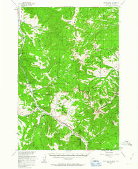
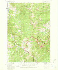
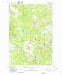
Editions of this 1955 Crown Butte Map
5 editions found
Historical Maps of Park County Through Time
84 maps found

1948 Sixteen
Gallatin County, MT

1949 Anceney
Gallatin County, MT

1949 Maudlow
Gallatin County, MT

1950 Hebgen Dam
Gallatin County, MT

1951 Bozeman Pass
Gallatin County, MT

1951 Hatfield Mountain
Gallatin County, MT

1951 Wallrock
Gallatin County, MT

1955 Crown Butte
Gallatin County, MT

1955 Garnet Mountain
Gallatin County, MT

1958 Tepee Creek
Gallatin County, MT

1986 Big Horn Peak
Gallatin County, MT

1986 Blacktail Mountain
Gallatin County, MT

1986 Francis
Gallatin County, MT

1986 Jack Straw Basin
Gallatin County, MT

1986 Lone Indian Peak
Gallatin County, MT

1986 Madison Arm
Gallatin County, MT

1986 Maudlow
Gallatin County, MT

1986 Mount Hebgen
Gallatin County, MT

1986 Ramshorn Peak
Gallatin County, MT

1986 Richards Creek
Gallatin County, MT

1986 Roy Gulch
Gallatin County, MT

1986 Sunshine Point
Gallatin County, MT

1986 Upper Tepee Basin
Gallatin County, MT

1987 Bozeman Hot Springs
Gallatin County, MT

1987 Bozeman Pass
Gallatin County, MT

1987 Flathead Pass
Gallatin County, MT

1987 Grassy Mountain
Gallatin County, MT

1987 Horseshoe Creek
Gallatin County, MT

1987 Kelly Creek
Gallatin County, MT

1987 Madison Plateau
Gallatin County, MT

1987 Manhattan SW
Gallatin County, MT

1987 Miser Creek
Gallatin County, MT

1987 Mount Ellis
Gallatin County, MT

1987 Nixon Gulch
Gallatin County, MT

1987 Norris NE
Gallatin County, MT

1987 Ruby Mountain
Gallatin County, MT

1987 Sacagawea Peak
Gallatin County, MT

1987 Saddle Peak
Gallatin County, MT

1987 Three Forks SE
Gallatin County, MT

1987 Wheeler Mountain
Gallatin County, MT

1988 Anceney
Gallatin County, MT

1988 Beacon Point
Gallatin County, MT

1988 Fridley Peak
Gallatin County, MT

1988 Gallatin Peak
Gallatin County, MT

1988 Garnet Mountain
Gallatin County, MT

1988 Hebgen Dam
Gallatin County, MT

1988 Hidden Lake
Gallatin County, MT

1988 Lincoln Mountain
Gallatin County, MT

1988 Mount Blackmore
Gallatin County, MT

1988 Ousel Falls
Gallatin County, MT

1988 Pika Point
Gallatin County, MT

1988 The Sentinel
Gallatin County, MT

2000 Beacon Point
Gallatin County, MT

2000 Big Horn Peak
Gallatin County, MT

2000 Blacktail Mountain
Gallatin County, MT

2000 Bozeman Pass
Gallatin County, MT

2000 Flathead Pass
Gallatin County, MT

2000 Fridley Peak
Gallatin County, MT

2000 Garnet Mountain
Gallatin County, MT

2000 Grassy Mountain
Gallatin County, MT

2000 Hatfield Mountain
Gallatin County, MT

2000 Hebgen Dam
Gallatin County, MT

2000 Hidden Lakes
Gallatin County, MT

2000 Jack Straw Basin
Gallatin County, MT

2000 Kelly Creek
Gallatin County, MT

2000 Lincoln Mountain
Gallatin County, MT

2000 Lone Indian Peak
Gallatin County, MT

2000 Madison Arm
Gallatin County, MT

2000 Miser Creek
Gallatin County, MT

2000 Mount Blackmore
Gallatin County, MT

2000 Mount Ellis
Gallatin County, MT

2000 Mount Hebgen
Gallatin County, MT

2000 Ousel Falls
Gallatin County, MT

2000 Pika Point
Gallatin County, MT

2000 Ramshorn Peak
Gallatin County, MT

2000 Richards Creek
Gallatin County, MT

2000 Ruby Mountain
Gallatin County, MT

2000 Sacagawea Peak
Gallatin County, MT

2000 Saddle Peak
Gallatin County, MT

2000 Sunshine Point
Gallatin County, MT

2000 The Sentinel
Gallatin County, MT

2000 Upper Tepee Basin
Gallatin County, MT

2000 Wallrock
Gallatin County, MT

2000 Wheeler Mountain
Gallatin County, MT