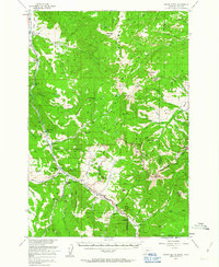
1955 Map of Crown Butte
USGS Topo · Published 1963About this map
The Gallatin River valley serves as the primary corridor for travel and settlement in this mid-century survey, with U.S. 191 following the water north to south. This era is defined by a dense network of guest ranches and mountain lodges that supported a growing recreation economy, including the 320 Ranch, Elkhorn Ranch, and Rainbow Ranch. To the east, the high country of the Gallatin National Forest is mapped with extensive pack trails and primitive routes reaching landmarks like Ramshorn Peak and Fortress Mountain.
Find a feature on this map
74 named features on this map. Tap any name to fly to it.
Don’t see what you’re looking for? This feature index may not catch every label — zoom into the map to look around manually.
Map Details
Editions of this 1955 Crown Butte Map
5 editions found

Other maps of this area

1885 · Gallatin
USGS Topo · 1:125,000

1885 · Gallatin
USGS Topo · 1:125,000

1888 · Three Forks
USGS Topo · 1:250,000

1891 · Livingston
USGS Topo · 1:250,000

1893 · Livingston
USGS Topo · 1:250,000

1894 · Three Forks
USGS Topo · 1:250,000

1895 · Three Forks
USGS Topo · 1:250,000

1901 · Gallatin
USGS Topo · 1:125,000

1908 · Gallatin
USGS Topo · 1:125,000

1911 · Gallatin
USGS Topo · 1:125,000