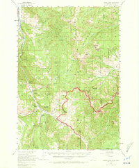
1955 Map of Crown Butte
USGS Topo · Published 1972About this map
Gallatin National Forest and the northern reaches of Yellowstone National Park converge in this mid-century survey, revealing a landscape defined by ranching, early tourism, and conservation. Along the Gallatin River and the corridor of U.S. 191, a series of established waypoints like Porcupine Ranch, Rainbow Ranch, and the Almart Mtn Lodge highlight the area's role as a gateway for mountain recreation. Educational and administrative history is anchored by the Ophir Sch and the Gallatin Ranger Station. The map captures a high-elevation wilderness including Crown Butte and Lava Butte, where the Gallatin Game Preserve protects the headwaters of numerous drainages like Elkhorn Creek and Specimen Creek. Traditional mountain passes, such as Tom Miner Pass, connect these drainages, marking the historical routes through the Gallatin and Park County line before modern infrastructure dominated the interior.
Find a feature on this map
76 named features on this map. Tap any name to fly to it.
Don’t see what you’re looking for? This feature index may not catch every label — zoom into the map to look around manually.
Map Details
Editions of this 1955 Crown Butte Map
5 editions found

Other maps of this area

1885 · Gallatin
USGS Topo · 1:125,000

1885 · Gallatin
USGS Topo · 1:125,000

1888 · Three Forks
USGS Topo · 1:250,000

1891 · Livingston
USGS Topo · 1:250,000

1893 · Livingston
USGS Topo · 1:250,000

1894 · Three Forks
USGS Topo · 1:250,000

1895 · Three Forks
USGS Topo · 1:250,000

1901 · Gallatin
USGS Topo · 1:125,000

1908 · Gallatin
USGS Topo · 1:125,000

1911 · Gallatin
USGS Topo · 1:125,000