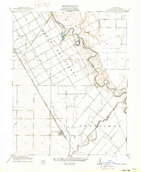
1916 Map of Crows Landing
USGS Topo · Published 1916About this map
The irrigated agricultural landscape of Stanislaus County is clearly visible in this 1914 survey, which depicts the transformation of former land grants like Rancho Del Puerto and Orestimba. The engineered layout of the Central Valley is evident in the dense network of Lateral ditches branching from the Main Canal, a system managed by the San Joaquin and Kings River Canal Company. This infrastructure contrasts sharply with the wandering, natural meanders of the San Joaquin River and its associated features like Pool and Slough.
Find a feature on this map
13 named features on this map. Tap any name to fly to it.
Don’t see what you’re looking for? This feature index may not catch every label — zoom into the map to look around manually.
Map Details
Editions of this 1916 Crows Landing Map
2 editions found
Other maps of this area

1915 · Westport
USGS Topo · 1:31,680

1915 · Westley
USGS Topo · 1:31,680

1916 · Mitchell School
USGS Topo · 1:31,680

1916 · Crows Landing
USGS Topo · 1:31,680

1916 · Patterson
USGS Topo · 1:31,680

1916 · Ceres
USGS Topo · 1:31,680

1917 · Newman
USGS Topo · 1:31,680

1918 · Gustine
USGS Topo · 1:31,680

1919 · Orestimba
USGS Topo · 1:62,500

1919 · Orestimba Creek
USGS Topo · 1:31,680