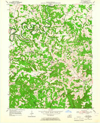
1954 Map of Cub Run
USGS Topo · Published 1965About this map
Nolin River meanders deeply through the limestone terrain of northern Hart County in the mid-1950s, creating a landscape defined by dramatic bends and subterranean features. This survey captures the rural character of the region before the creation of the Nolin River Lake reservoir, showing the original course of the river past Blowing Springs and the early Gaging Sta near Wax. The map identifies numerous small rural centers like Roseburg, Cub Run, and Center Point, which served as anchors for the surrounding farmsteads and hollows.
Find a feature on this map
45 named features on this map. Tap any name to fly to it.
Don’t see what you’re looking for? This feature index may not catch every label — zoom into the map to look around manually.
Map Details
Editions of this 1954 Cub Run Map
2 editions found
Other maps of this area

1922 · Mammoth Cave
USGS Topo · 1:62,500

1923 · Mammoth Cave
USGS Topo · 1:62,500

1925 · Cub Run
USGS Topo · 1:62,500

1934 · Munfordville
USGS Topo · 1:48,000

1935 · Horse Cave
USGS Topo · 1:48,000

1937 · Munfordville
USGS Topo · 1:62,500

1938 · Horse Cave
USGS Topo · 1:62,500

1953 · Munfordville
USGS Topo · 1:24,000

1954 · Evansville
USGS Topo · 1:250,000

1954 · Horse Cave
USGS Topo · 1:24,000