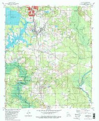
1981 Map of Cullen
USGS Topo · Published 1981About this map
Industrial and agricultural development define the landscape north of the Bossier Parish and Webster Parish line in the early 1980s. The northern corridor is anchored by Springhill and Cullen, where the Louisiana and Arkansas railroad serves heavy industry, including operations near the Paper Mill Pond and the extensive South Sarepta Oil and Gas Field. This era of growth is balanced by the preservation of the Bodcau State Wildlife Management Area, which protects the wetlands surrounding the Bayou Bodcau Reservoir. Genealogists will find a high density of burial sites throughout the quadrangle, including the Slack Memorial Cem and the Garden of Memory Cem. Smaller, rural communities such as Porterville, Baccus, and Sarepta maintain their identities through landmarks like St Mariah Cem and the Blocker Ch, while the terrain is marked by numerous oil wells and gravel extractions.
Find a feature on this map
54 named features on this map. Tap any name to fly to it.
Don’t see what you’re looking for? This feature index may not catch every label — zoom into the map to look around manually.
Map Details
Editions of this 1981 Cullen Map
2 editions found
Other maps of this area

1922 · Sarepta
USGS Topo · 1:62,500

1924 · Sarepta
USGS Topo · 1:62,500

1950 · Plain Dealing NE
USGS Topo · 1:31,680

1950 · Plain Dealing SE
USGS Topo · 1:31,680

1952 · Bradley SE
USGS Topo · 1:24,000

1953 · Carterville
USGS Topo · 1:24,000

1953 · El Dorado
USGS Topo · 1:250,000

1955 · Shreveport
USGS Topo · 1:250,000
1955 · Plain Dealing
USGS Topo · 1:62,500

1956 · Shreveport
USGS Topo · 1:250,000