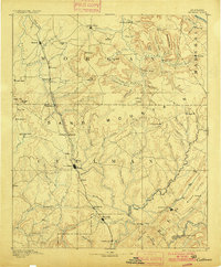
1892 Map of Cullman
USGS Topo · Published 1900About this map
Louisville and Nashville Railroad tracks dominate the central corridor of this North Alabama landscape, driving the growth of late-nineteenth-century trackside towns. The geography is defined by the significant rise of Sand Mountain, where early settlements like Cullman, Hanceville, and Falkville emerged as vital centers of commerce and transport. The map reveals a transition from the agricultural lowlands of Morgan County into the more dissected plateaus of the south, punctuated by natural landmarks such as Cotacco Falls and the deep depressions of Newsome Sinks.
Find a feature on this map
101 named features on this map. Tap any name to fly to it.
Don’t see what you’re looking for? This feature index may not catch every label — zoom into the map to look around manually.
Map Details
Editions of this 1892 Cullman Map
4 editions found
Other maps of this area

1885 · Gadsden
USGS Topo · 1:125,000

1888 · Cullman
USGS Topo · 1:125,000

1888 · Gadsden
USGS Topo · 1:125,000

1888 · Scottsboro
USGS Topo · 1:125,000

1888 · Huntsville
USGS Topo · 1:125,000

1889 · Springville
USGS Topo · 1:125,000

1889 · Birmingham
USGS Topo · 1:125,000

1892 · Cullman
USGS Topo · 1:125,000

1892 · Birmingham
USGS Topo · 1:125,000

1892 · Springville
USGS Topo · 1:125,000