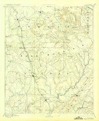
1892 Map of Cullman
USGS Topo · Published 1924About this map
Cullman and its surrounding uplands are defined by the Louisville and Nashville Railroad, which serves as the primary artery through this North Alabama landscape in the late nineteenth century. The rail line dictates the placement of burgeoning towns like Hartsell, Falkville, and Hanceville, while older inland hubs like Somerville and Blountsville maintain their positions away from the tracks.
Find a feature on this map
97 named features on this map. Tap any name to fly to it.
Don’t see what you’re looking for? This feature index may not catch every label — zoom into the map to look around manually.
Map Details
Editions of this 1892 Cullman Map
4 editions found
Other maps of this area

1885 · Gadsden
USGS Topo · 1:125,000

1888 · Cullman
USGS Topo · 1:125,000

1888 · Gadsden
USGS Topo · 1:125,000

1888 · Scottsboro
USGS Topo · 1:125,000

1888 · Huntsville
USGS Topo · 1:125,000

1889 · Springville
USGS Topo · 1:125,000

1889 · Birmingham
USGS Topo · 1:125,000

1892 · Cullman
USGS Topo · 1:125,000

1892 · Birmingham
USGS Topo · 1:125,000

1892 · Springville
USGS Topo · 1:125,000