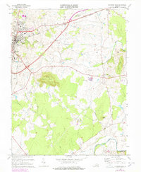
1973 Map of Culpeper East
USGS Topo · Published 1978About this map
Culpeper and its eastern environs are captured here in the 1970s, showcasing the transition from the town's residential center to the surrounding Piedmont farmland. The Southern railway tracks bisect the landscape, linking the county seat to Brandy Station and Inlet to the northeast. Notable community infrastructure is prominent, from the National Cem and Masonic Cem near the town center to the County High Sch and Richardson Sch.
Find a feature on this map
49 named features on this map. Tap any name to fly to it.
Don’t see what you’re looking for? This feature index may not catch every label — zoom into the map to look around manually.
Map Details
Editions of this 1973 Culpeper East Map
4 editions found
Other maps of this area

1887 · Spottsylvania
USGS Topo · 1:125,000

1892 · Spottsylvania
USGS Topo · 1:125,000

1892 · Gordonsville
USGS Topo · 1:125,000

1893 · Luray
USGS Topo · 1:125,000

1894 · Warrenton
USGS Topo · 1:125,000

1894 · Warrenton
USGS Topo · 1:62,500

1905 · Luray
USGS Topo · 1:125,000

1927 · Remington
USGS Topo · 1:48,000

1930 · Warrenton
USGS Topo · 1:62,500

1943 · Germanna Bridge
USGS Topo · 1:24,000