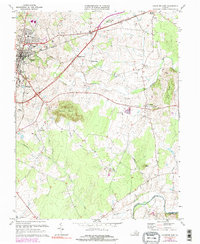
1973 Map of Culpeper East
USGS Topo · Published 1981About this map
Culpeper stands as the primary hub of this northern Virginia landscape in the early 1970s, situated where the Southern railroad meets a network of developing roads and residential growth. The town's historical weight is anchored by the National Cem, while local institutions like the County High Sch and Jr High Sch define the community core. To the east, the landscape transitions into a series of smaller rural nodes and family-named intersections such as Braggs Corner and Greens Corner, eventually reaching the established village of Stevensburg.
Find a feature on this map
39 named features on this map. Tap any name to fly to it.
Don’t see what you’re looking for? This feature index may not catch every label — zoom into the map to look around manually.
Map Details
Editions of this 1973 Culpeper East Map
4 editions found
Other maps of this area

1887 · Spottsylvania
USGS Topo · 1:125,000

1892 · Spottsylvania
USGS Topo · 1:125,000

1892 · Gordonsville
USGS Topo · 1:125,000

1893 · Luray
USGS Topo · 1:125,000

1894 · Warrenton
USGS Topo · 1:125,000

1894 · Warrenton
USGS Topo · 1:62,500

1905 · Luray
USGS Topo · 1:125,000

1927 · Remington
USGS Topo · 1:48,000

1930 · Warrenton
USGS Topo · 1:62,500

1943 · Germanna Bridge
USGS Topo · 1:24,000