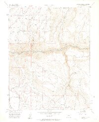
1956 Map of Curecanti Needle
USGS Topo · Published 1963About this map
The Curecanti Needle stands as a prominent landmark along the Gunnison River in this mid-century topographic study, which documents the landscape just before significant Bureau of Reclamation water projects altered the river's character. The deep gorge of the Black Canyon of the Gunnison dominates the central terrain, bordered by the Gunnison National Forest. Evidence of early cattle ranching and remote settlement is scattered across the mesas and gulches, including the McLeod Ranch and Knott Ranch, while the Rimrock Sch (Aband) reflects the shifting population of this isolated Colorado region. The map captures a transition toward modern infrastructure with the appearance of a Microwave Relay Sta and a Gaging Sta along the water, even as much of the area remains accessible only by a primitive Jeep Trail.
Find a feature on this map
30 named features on this map. Tap any name to fly to it.
Don’t see what you’re looking for? This feature index may not catch every label — zoom into the map to look around manually.
Map Details
Editions of this 1956 Curecanti Needle Map
5 editions found
Other maps of this area

1908 · Uncompahgre
USGS Topo · 1:125,000

1909 · Montrose
USGS Topo · 1:125,000

1911 · Uncompahgre
USGS Topo · 1:125,000

1911 · Montrose
USGS Topo · 1:125,000

1954 · Little Soap Park
USGS Topo · 1:24,000

1954 · Sapinero
USGS Topo · 1:24,000

1956 · Curecanti Needle
USGS Topo · 1:24,000

1956 · Cimarron
USGS Topo · 1:24,000

1956 · Montrose
USGS Topo · 1:250,000

1957 · Cathedral Peak
USGS Topo · 1:24,000