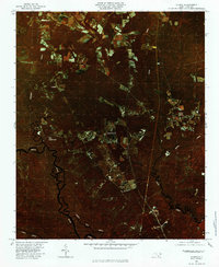
1980 Map of Currie
USGS Topo · Published 1985About this map
Black River meanders through the western portion of this 1980 color infrared orthophotoquad, defining a landscape where dense swampland meets a network of agricultural clearings. The transition from the dark, wooded floodplains of the river to the upland settlements is sharp, with scattered residential and farming clusters like The Borough and Montague situated along the primary north-south corridor. The imagery reveals the intricate hydrology of Pender County, showing how the winding courses of Moores Creek and Rileys Creek feed into the larger river system.
Find a feature on this map
11 named features on this map. Tap any name to fly to it.
Don’t see what you’re looking for? This feature index may not catch every label — zoom into the map to look around manually.
Map Details
Editions of this 1980 Currie Map
This is the sole edition of this map. No revisions or reprints were ever made.
Other maps of this area

1942 · Burgaw
USGS Topo · 1:62,500

1947 · Rocky Point
USGS Topo · 1:62,500

1953 · Florence
USGS Topo · 1:250,000

1953 · Beaufort
USGS Topo · 1:250,000

1954 · Florence
USGS Topo · 1:250,000

1954 · Beaufort
USGS Topo · 1:250,000

1954 · Acme
USGS Topo · 1:62,500

1955 · Atkinson
USGS Topo · 1:62,500
1970 · Castle Hayne
USGS Topo · 1:24,000
1970 · Rocky Point
USGS Topo · 1:24,000