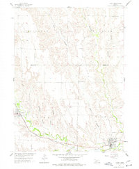
1956 Map of Curtis
USGS Topo · Published 1977About this map
Medicine Creek and its tributaries carve a network of deep drainage across this Nebraska landscape, framing the settlements of Curtis and Maywood during the mid-1950s. The topography is defined by prominent upland divides such as Buchanan and Laird, which separate numerous named draws including Ackenson Canyon and Staples Canyon. The Chicago Burlington and Quincy railroad follows the winding path of the creek valley, serving as the primary transportation artery connecting these rural communities.
Find a feature on this map
17 named features on this map. Tap any name to fly to it.
Don’t see what you’re looking for? This feature index may not catch every label — zoom into the map to look around manually.
Map Details
Editions of this 1956 Curtis Map
2 editions found
Other maps of this area

1902 · Gothenburg
USGS Topo · 1:125,000

1954 · McCook
USGS Topo · 1:250,000

1956 · Jeffrey Reservoir SW
USGS Topo · 1:24,000

1956 · Curtis SW
USGS Topo · 1:24,000

1956 · Moorefield
USGS Topo · 1:24,000

1956 · Curtis NW
USGS Topo · 1:24,000

1956 · Curtis
USGS Topo · 1:24,000

1956 · Curtis SE
USGS Topo · 1:24,000

1956 · Stockville
USGS Topo · 1:24,000

1956 · Wellfleet SE
USGS Topo · 1:24,000