
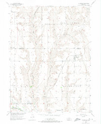
1956 Map of Moorefield
USGS Topo · Published 1957About this map
Moorefield sits at a geographic crossroads in Frontier County, where the plains are deeply dissected by the intricate drainage systems of Fox Creek, Medicine Creek, and Deer Creek. This mid-century survey reveals a rural landscape defined by its agricultural community infrastructure, featuring a high density of country schoolhouses such as Bethel Sch, Windy Ridge Sch, and Pleasant Home Sch. The Chicago Burlington and Quincy railroad cuts through the southern reaches, following the valley of Medicine Creek, while the Curtis Municipal Airport serves as a modern landmark for the neighboring East Curtis area. Significant local history markers include the Moorefield Cemetery and the Pleasant Home Church, reflecting the established social fabric of the Nebraska plains during the post-war era.
Find a feature on this map
25 named features on this map. Tap any name to fly to it.
Don’t see what you’re looking for? This feature index may not catch every label — zoom into the map to look around manually.
Map Details
Editions of this 1956 Moorefield Map
2 editions found
Other maps of this area

1902 · Gothenburg
USGS Topo · 1:125,000

1954 · McCook
USGS Topo · 1:250,000

1956 · Jeffrey Reservoir SW
USGS Topo · 1:24,000

1956 · Stockville NE
USGS Topo · 1:24,000

1956 · Curtis
USGS Topo · 1:24,000

1956 · Curtis SE
USGS Topo · 1:24,000

1956 · Stockville
USGS Topo · 1:24,000

1956 · Wellfleet SE
USGS Topo · 1:24,000

1956 · Stockville SE
USGS Topo · 1:24,000

1957 · McCook
USGS Topo · 1:250,000