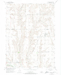
1956 Map of Moorefield
USGS Topo · Published 1974About this map
Moorefield serves as the primary hub on this mid-century survey, situated at the junction of the Chicago Burlington and Quincy railroad line and local prairie roads. The landscape is defined by the transition from the high plains of the Lincoln and Frontier county line into the deeply incised drainages of East Curtis Cr Canyon and Curtis Canyon. This geography influenced a pattern of dispersed rural development, where small community centers like the Pleasant Home Ch and Bethel Sch supported far-flung agricultural families.
Find a feature on this map
26 named features on this map. Tap any name to fly to it.
Don’t see what you’re looking for? This feature index may not catch every label — zoom into the map to look around manually.
Map Details
Editions of this 1956 Moorefield Map
2 editions found
Other maps of this area

1902 · Gothenburg
USGS Topo · 1:125,000

1954 · McCook
USGS Topo · 1:250,000

1956 · Jeffrey Reservoir SW
USGS Topo · 1:24,000

1956 · Stockville NE
USGS Topo · 1:24,000

1956 · Moorefield
USGS Topo · 1:24,000

1956 · Curtis
USGS Topo · 1:24,000

1956 · Curtis SE
USGS Topo · 1:24,000

1956 · Stockville
USGS Topo · 1:24,000

1956 · Wellfleet SE
USGS Topo · 1:24,000

1956 · Stockville SE
USGS Topo · 1:24,000