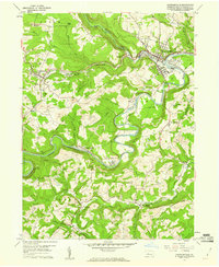
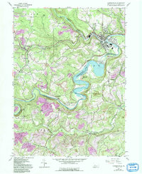
1959 Map of Curwensville
USGS Topo · Published 1960About this map
The West Branch Susquehanna River carves a deep, winding path through Clearfield County in the late 1950s, anchoring a landscape defined by industry and transportation. The borough of Curwensville serves as a major hub where the Baltimore and Ohio and Pennsylvania railroads converge, supporting a region active with numerous strip mines and quarries. Downriver, Lumber City and Bridgeport sit along the riverbanks, while the presence of the Good Brick Kilns near the river reflects the era's local manufacturing base.
Find a feature on this map
61 named features on this map. Tap any name to fly to it.
Don’t see what you’re looking for? This feature index may not catch every label — zoom into the map to look around manually.
Map Details
Editions of this 1959 Curwensville Map
5 editions found
Other maps of this area

1903 · Curwensville
USGS Topo · 1:62,500

1903 · Houtzdale
USGS Topo · 1:62,500

1905 · Houtzdale
USGS Topo · 1:62,500

1929 · Clearfield
USGS Topo · 1:48,000

1929 · Penfield
USGS Topo · 1:62,500

1932 · Clearfield
USGS Topo · 1:62,500

1932 · Penfield
USGS Topo · 1:62,500

1939 · Curwensville
USGS Topo · 1:62,500

1942 · Curwensville
USGS Topo · 1:62,500

1943 · Punxsutawney
USGS Topo · 1:125,000