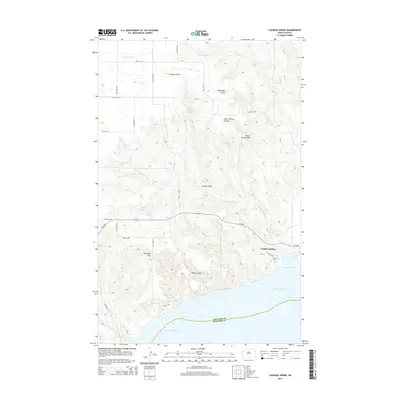
2014 Map of Cussicks Spring
USGS Topo · Published 2014About this map
Lunds Landing sits near the northeastern reaches of the massive Lake Sakakawea in this 2014 study of Williams and McKenzie counties. The landscape is defined by the complex drainage systems of the Missouri River plateau, where numerous named coulees and springs carve into the terrain. Distinctive landmarks such as Stone Johnny Hill and Flagstaff Hill rise above the surrounding prairies, while Tobacco Garden Cr winds its way toward White Tail Bay. The presence of several named water sources, including Mort Adams Spring, Hungry Gulch Spring, and the namesake Cussicks Spring, highlights the critical importance of localized water points in this semi-arid environment. The roadway network is dominated by ND-1804, tracing the high ground above the reservoir's northern shore.
Find a feature on this map
33 named features on this map. Tap any name to fly to it.
Don’t see what you’re looking for? This feature index may not catch every label — zoom into the map to look around manually.
Map Details
Editions of this 2014 Cussicks Spring Map
This is the sole edition of this map. No revisions or reprints were ever made.
Other maps of this area

1911 · Ray
USGS Topo · 1:125,000

1953 · Williston
USGS Topo · 1:250,000

1957 · Williston
USGS Topo · 1:250,000

1969 · Cussicks Spring
USGS Topo · 1:24,000

1969 · Red Mike Hill
USGS Topo · 1:24,000

1978 · Ray
USGS Topo · 1:24,000

1978 · Tobacco Garden Bay
USGS Topo · 1:24,000

1978 · Ray SE
USGS Topo · 1:24,000

1978 · Epping
USGS Topo · 1:24,000
1978 · Banks
USGS Topo · 1:24,000