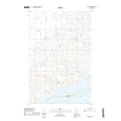
2017 Map of Cussicks Spring
USGS Topo · Published 2017About this map
Lake Sakakawea and the winding Missouri River dominate the southern reach of this landscape along the border of Williams and McKenzie counties. The terrain is defined by deep drainage systems such as Stone Johnny Coulee and Cedar Coulee, which cut through the high ground of the Missouri Plateau. Named high points like Flagstaff Hill and Stone Johnny Hill offer perspective over a region where water sources are vital, marked by several recorded springs including Mort Adams Spring and the namesake Cussicks Spring. The map documents a sparse, rural infrastructure of township roads and section lines, with White Tail Bay providing an inlet for the expansive reservoir. This area retains much of its traditional character, showing the intricate relationship between the prairie coulees and the massive Missouri River drainage system as it appeared in recent years.
Find a feature on this map
35 named features on this map. Tap any name to fly to it.
Don’t see what you’re looking for? This feature index may not catch every label — zoom into the map to look around manually.
Map Details
Editions of this 2017 Cussicks Spring Map
This is the sole edition of this map. No revisions or reprints were ever made.
Other maps of this area

1911 · Ray
USGS Topo · 1:125,000

1953 · Williston
USGS Topo · 1:250,000

1957 · Williston
USGS Topo · 1:250,000

1969 · Cussicks Spring
USGS Topo · 1:24,000

1969 · Red Mike Hill
USGS Topo · 1:24,000

1978 · Ray
USGS Topo · 1:24,000

1978 · Tobacco Garden Bay
USGS Topo · 1:24,000

1978 · Ray SE
USGS Topo · 1:24,000

1978 · Epping
USGS Topo · 1:24,000
1978 · Banks
USGS Topo · 1:24,000