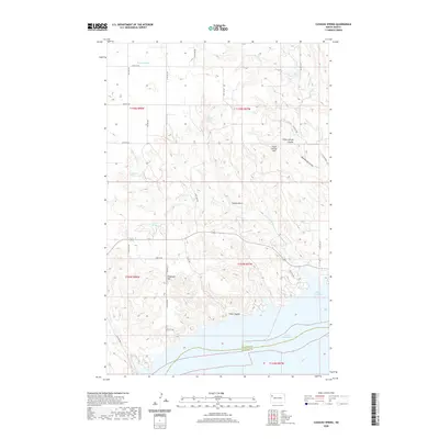
2020 Map of Cussicks Spring
USGS Topo · Published 2020About this map
Lake Sakakawea dominates the southern landscape of this Missouri River basin quadrangle, where the boundary between Williams Co and McKenzie Co follows the submerged channel. The terrain north of the reservoir is defined by a network of deep drainage coulees and high points named for local history and topography, including Stone Johnny Hill, Flagstaff Hill, and the long descent of Half Breed Coulee. The presence of several named water sources such as Cussicks Spring, Mort Adams Spring, and Hungry Gulch Spring suggests the vital importance of reliable water in this arid prairie environment. Long, straight section-line roads like 118th Ave NW and 57th St NW grid the uplands, providing access to the rugged draws and points like White Tail Bay and Cedar Coulee that overlook the expansive water of the bay.
Find a feature on this map
36 named features on this map. Tap any name to fly to it.
Don’t see what you’re looking for? This feature index may not catch every label — zoom into the map to look around manually.
Map Details
Editions of this 2020 Cussicks Spring Map
This is the sole edition of this map. No revisions or reprints were ever made.
Other maps of this area

1911 · Ray
USGS Topo · 1:125,000

1953 · Williston
USGS Topo · 1:250,000

1957 · Williston
USGS Topo · 1:250,000

1969 · Cussicks Spring
USGS Topo · 1:24,000

1969 · Red Mike Hill
USGS Topo · 1:24,000

1978 · Ray
USGS Topo · 1:24,000

1978 · Tobacco Garden Bay
USGS Topo · 1:24,000

1978 · Ray SE
USGS Topo · 1:24,000

1978 · Epping
USGS Topo · 1:24,000
1978 · Banks
USGS Topo · 1:24,000