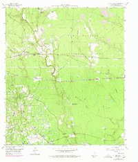
1959 Map of Cut and Shoot
USGS Topo · Published 1978About this map
The Conroe Oil Field and the surrounding piney woods of southeastern Texas define this landscape during a period of steady industrial and rural development. Evidence of the region’s timber and petroleum economy is visible in the network of pipelines, Gravel Pits, and Sludge Pits that dot the terrain between Caney Creek and the East Fork San Jacinto River. Significant local history is captured in small, established communities such as Cut and Shoot, Groceville, and Waukegan, which are serviced by the Atchison Topeka and Santa Fe railroad.
Find a feature on this map
41 named features on this map. Tap any name to fly to it.
Don’t see what you’re looking for? This feature index may not catch every label — zoom into the map to look around manually.
Map Details
Editions of this 1959 Cut and Shoot Map
3 editions found
Other maps of this area

1954 · Beaumont
USGS Topo · 1:250,000

1957 · Beaumont
USGS Topo · 1:250,000

1958 · Conroe
USGS Topo · 1:24,000

1958 · Fostoria
USGS Topo · 1:24,000

1958 · Bear Creek
USGS Topo · 1:24,000

1959 · Outlaw Pond
USGS Topo · 1:24,000

1959 · Cut and Shoot
USGS Topo · 1:24,000

1959 · Conroe NE
USGS Topo · 1:24,000
1959 · Splendora
USGS Topo · 1:24,000

1960 · Willis
USGS Topo · 1:24,000