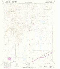
1966 Map of Cuyler
USGS Topo · Published 1979About this map
Atchison Topeka and Santa Fe railroad tracks cut across the southeastern corner of this Panhandle landscape, anchoring the small siding at Cuyler. This region is defined by the heavy footprint of the energy and agricultural industries, featuring a sprawling Oil Field and numerous Oil Wells that dot the plains between East Dixon Creek and West Bear Creek. The industrial character of the era is further emphasized by the presence of a Grain Elevator at the rail line and several Gravel Pits to the northwest. Surveyed in the mid-1960s with late-1970s updates, the map captures a transition in Texas land use, where traditional ranching terrain is overlaid with a dense network of modern infrastructure including a large Pipeline system and the small settlement of Simms.
Find a feature on this map
11 named features on this map. Tap any name to fly to it.
Don’t see what you’re looking for? This feature index may not catch every label — zoom into the map to look around manually.
Map Details
Editions of this 1966 Cuyler Map
2 editions found
Other maps of this area

1953 · Borger SE
USGS Topo · 1:24,000

1953 · McBride
USGS Topo · 1:24,000

1954 · Amarillo
USGS Topo · 1:250,000

1958 · Amarillo
USGS Topo · 1:250,000

1963 · Skellytown
USGS Topo · 1:24,000

1965 · White Deer
USGS Topo · 1:24,000

1965 · Abell
USGS Topo · 1:24,000

1966 · Panhandle West
USGS Topo · 1:24,000

1966 · Panhandle East
USGS Topo · 1:24,000

1966 · Cuyler
USGS Topo · 1:24,000